


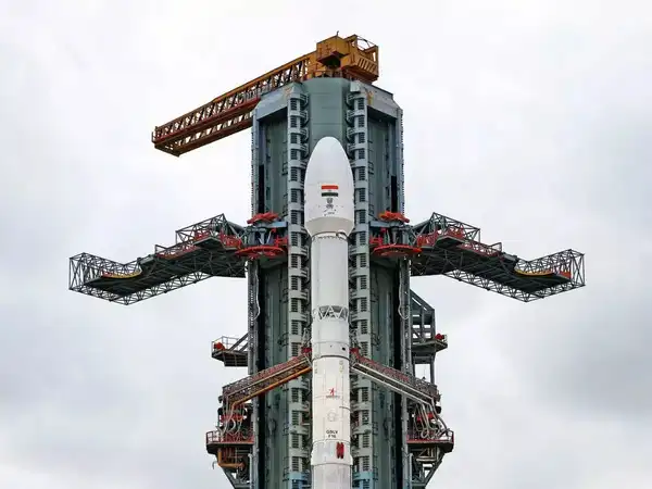
In a landmark moment for space collaboration, the NASA-ISRO NISAR satellite was successfully launched into orbit on Wednesday evening from the Satish Dhawan Space Centre, Sriharikota. The GSLV-F16 rocket lifted off at 5:40 PM IST, marking a significant milestone in Indo-U.S. space cooperation and Earth observation capabilities.
The NISAR mission launch concluded successfully as the 2,392-kg satellite separated from the launch vehicle and was injected precisely into a sun-synchronous orbit 18 minutes after liftoff. This achievement reinforces India’s growing prominence in global space missions and deepens its scientific collaboration with the United States.
What is the NISAR Satellite?
NISAR stands for NASA-ISRO Synthetic Aperture Radar, the world’s first Earth observation satellite to employ a dual-frequency SAR combining NASA’s L-band and ISRO’s S-band radars. The mission will monitor land and ice deformation, track changes in land ecosystems, observe oceanic patterns, and enhance global understanding of natural hazards and climate change.
“This mission is a game-changer,” said ISRO Chairman V. Narayanan. “NISAR will detect even minute changes on Earth’s surface,from glacial movements and vegetation changes to mapping soil moisture and disaster response.”
The radar system is equipped with NASA’s 12-metre unfurlable mesh reflector antenna, mounted on ISRO’s I3K satellite bus, making it one of the most advanced Earth observation satellites ever deployed.
Key NISAR Mission Features:
- Launch site: Satish Dhawan Space Centre Sriharikota
- Launch vehicle: GSLV-F16
- NISAR mission countdown began early morning July 30
- NISAR mission lift off time: 5:40 PM IST
- Dual-frequency SAR: NASA’s L-band and ISRO’s S-band
- Applications: Ground deformation, sea-ice tracking, ship detection, shoreline mapping, disaster response, and more.
Why the NISAR Mission Matters
The NASA-ISRO mission will generate massive volumes of data to support scientists, policymakers, and disaster management agencies. Its data will also be crucial in studying the Earth’s crustal movements, earthquakes, landslides, and changes in water bodies. This real-time and continuous monitoring will be available globally, furthering transparency and collaboration across scientific communities.
According to space analysts, NISAR not only strengthens Indo-U.S. scientific ties but also demonstrates the engineering prowess of Indian space technology on a global stage.


More Stories
India’s “Boycott Thailand” Movement Trends Online Over Demolition of Vishnu Statue at Thailand-Cambodia Border
The rupee sinks to an all-time low against the US dollar as currency pressure mounts.
PM Narendra Modi Embarks on Crucial Four-Day Tour to Jordan, Ethiopia and Oman