


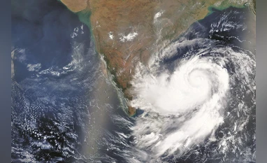
With the India Meteorological Department sounding an alert over Cyclonic Storm Ditwah, coastal and southern India brace for heavy to extremely heavy rainfall, strong winds, and possible flooding. The cyclone, currently over Sri Lanka and the southwest Bay of Bengal, is expected to hit the north Tamil Nadu–Puducherry coast by early November 30 — prompting urgent precautionary measures.
Alerts, Rainfall & Wind Forecast
- A red alert over heavy rainfall of more than 20 cm in 24 hours has been declared for several coastal districts, including Cuddalore, Mayiladuthurai, Villupuram, Chengalpattu and Puducherry.
- Also, the forecast mentions very heavy rainfall over many other regions, with lighter rain in some interior areas.
- The wind speed is most likely to reach 70-80 kmph, gusting to 90 kmph, which may uproot trees and damage hoardings and mud or thatched houses.
- Outer bands of Ditwah may also bring squally winds over parts of the Arabian Sea — impacting regions like Kerala, Lakshadweep, and the Maldives with wind speeds of 35–45 km/h, gusting to 55 km/h.
Impacted Regions Beyond Tamil Nadu & Puducherry
While the immediate alert is focused on the north Tamil Nadu–Puducherry coast, IMD warns of potential rain and rough seas across several southern states:
- Light to moderate rain is probable in Kerala, with isolated heavy showers.
- The Met forecast said that coastal Andhra Pradesh, Rayalaseema and south Andhra would receive heavy to very heavy rainfall, especially as Ditwah moves inland.
Parts of Telangana might also get heavy rain.
Likely Disruptions & Warnings
Officials have warned of a range of risks, including:
- Localised flooding and waterlogging, particularly in urban areas and low-lying regions.
- Damage to the crops, especially horticulture, floriculture, and vegetables in the stage of ripening.
- Hazardous sea conditions, with high waves and rough sea state, make fishing or boating extremely dangerous. Fisherfolk are advised to avoid the Bay of Bengal and Gulf of Mannar during the next few days.
- Threat to public safety – with chances of uprooting trees, fallen signboards, and damage to weak structures.
What to Expect Over the Next Few Days
According to the updated IMD bulletin:
- The cyclone is most likely to emerge from Sri Lanka and enter the southwest Bay of Bengal by the morning of November 29. A slight intensification is possible before landfall.
- Rainfall and wind will remain intense over coastal Tamil Nadu and Puducherry from Saturday into Sunday, Nov. 29–30.
- After the peak — which may be on November 30 — rain will start gradually easing. Light to moderate rainfall may continue in some areas up to December 1.
Stay Alert: What Residents Should Do
- People in the coastal and low-lying areas should stay indoors and avoid travelling unless absolutely necessary until the cyclone crosses.
- Those in coastal, river, or flood area locations should relocate to higher ground if flood warnings worsen.
- Fishermen and operators of fishing boats should not venture into seas, particularly the Bay of Bengal and the Gulf of Mannar, at least in the next few days.
- Follow officially disseminated weather updates through IMD and local authorities for advisories and instructions.
Why “Ditwah” Matters: A Quick Context
The name “Ditwah” comes from the Detwah Lagoon in Yemen — chosen under the naming convention maintained by the World Meteorological Organization, or WMO, and associated panels. The system behind Ditwah formed on November 26, 2025, and is part of the active 2025 North Indian Ocean cyclone season.
With Ditwah coming closer, south India faces one of the most widespread cyclonic alerts this season, thus making awareness, preparedness, and caution all the more imperative.


More Stories
Long Covid May Damage Dopamine-Producing Brain Cells, New Study
US Health Watchdog Projects $5.56 Billion in Recoveries and
Zari Enters Luxury Hospitality with the Launch of Bijapur Lodge in Jawai,